A Framework for Spatial Decision-Making
What is Rhino × GIS × AI?
English
Rhino × GIS × AI is a framework for spatial decision-making that connects form, position, and inference.
Rhino provides a way to create and explore geometry.
GIS provides position through geographic, environmental, and social information.
AI provides inference through prediction, classification, optimization, and pattern recognition.
Together, these disciplines help us understand not only what we design, but also where it exists and how decisions can be informed by data and context.
Rather than treating design, geography, and intelligence as separate domains, Rhino × GIS × AI seeks to connect them into a unified framework for understanding space.
日本語
Rhino × GIS × AI は、形状・位置・推論を結び付けることで、空間的意思決定を支援するためのフレームワークです。
Rhino は形状を扱います。
GIS は地理的・環境的・社会的な情報を通じて位置を扱います。
AI は予測、分類、最適化、パターン認識などの推論を行います。
これらを組み合わせることで、私たちは単に何を設計するかだけでなく、それがどこに存在し、どのような判断が求められるのかを理解できるようになります。
Rhino × GIS × AI は、設計、地理情報、人工知能を別々の領域として扱うのではなく、空間を理解するための統合的なフレームワークとして捉える試みです。
Why Rhino × GIS?
English
Rhino and GIS approach space from different reference frames.
Rhino typically begins with form and moves outward toward its surroundings.
GIS typically begins with the environment and moves inward toward specific locations, objects, and interventions.
Neither perspective is complete on its own.
Rhino enables exploration of possibilities.
GIS enables understanding of existing conditions.
By connecting both perspectives, design decisions can be evaluated within their geographic, environmental, and social context.
日本語
Rhino と GIS は、異なる参照系から空間を捉えます。
Rhino は形状から出発し、その外側にある環境へ向かいます。
GIS は環境から出発し、その内側にある対象や計画へ向かいます。
どちらか一方だけでは、空間を十分に理解することはできません。
Rhino は新たな可能性を探るための手段を提供します。
GIS は既存の環境や条件を理解するための手段を提供します。
両者を結び付けることで、設計対象を地理的・環境的・社会的文脈の中で評価することが可能になります。
A Concept Map
English
The framework can be summarized through four connected concepts:
Form — What are we creating?
Position — Where does it exist?
Inference — What can we learn or predict?
Decision — What should we do?
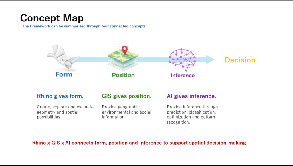
Position provides the foundation for context.
Rhino, GIS, and AI each contribute to one of these layers, creating a bridge between geometry, geography, and intelligence.
日本語
このフレームワークは、四つの概念によって整理できます。
Form(形状)
何をつくるのか。
Position(位置)
それはどこに存在するのか。
Inference(推論)
そこから何を読み取り、予測できるのか。
Decision(意思決定)
何を選択するべきなのか。
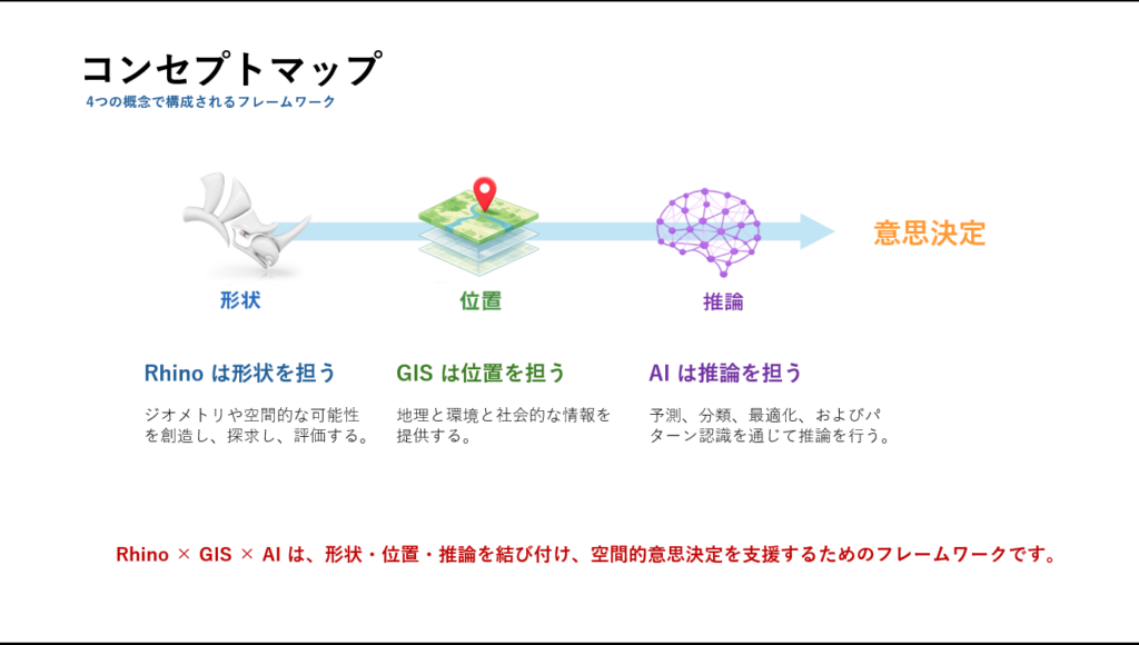
位置は文脈を理解するための基盤となります。
Rhino、GIS、AI はそれぞれ異なる層を担当しながら、形状・位置・推論を結び付ける役割を果たします。
Beyond Workflow
English
Rhino × GIS × AI is not merely a workflow.
A workflow describes a sequence of steps.
A framework describes a way of thinking.
More specifically, Rhino × GIS × AI is not a workflow, but a reference frame for understanding space.
Its value does not come from connecting software tools.
Its value comes from the ability to move between different reference frames and understand space from multiple perspectives.
日本語
Rhino × GIS × AI は単なるワークフローではありません。
ワークフローとは手順です。
フレームワークとは考え方です。
より正確に言えば、Rhino × GIS × AI はワークフローではなく、空間を理解するための参照系です。
その価値はソフトウェア同士を接続することではありません。
異なる参照系を行き来しながら、空間を多面的に理解できることにあります。
Toward Spatial Decision-Making
English
The ultimate goal of Rhino × GIS × AI is not modeling, mapping, or visualization.
The goal is better spatial decision-making.
Cities, buildings, infrastructure, and environments are shaped by countless interconnected factors.
Form alone is insufficient.
Position alone is insufficient.
AI alone is insufficient.
AI helps bridge form and position through inference.
By integrating form, position, and inference, it becomes possible to support more informed and transparent decisions about space.
日本語
Rhino × GIS × AI の最終目的は、モデリングや地図化、可視化そのものではありません。
目的は、より良い空間的意思決定を支援することです。
都市、建築、インフラ、環境は、多くの要素が複雑に関係しながら成り立っています。
形状だけでは不十分です。
位置だけでも不十分です。
AIだけでも不十分です。
AI は推論を通じて、形状と位置の間を橋渡しします。
形状・位置・推論を統合することで、空間に関する判断をより客観的かつ透明なものにすることができます。
Closing Statement
English
Rhino gives form.
GIS gives position.
AI gives inference.
Together, they provide a framework for spatial decision-making.
日本語
Rhino は形状を与える。
GIS は位置を与える。
AI は推論を与える。
それらは共に、空間的意思決定のためのフレームワークとなる。
Underlying Principle
English
The Rhino × GIS × AI Framework is a representative implementation of the broader principle of Spatial Intelligence Assemblage.
Learn about the underlying principle that connects interdisciplinary knowledge into spatial intelligence.
日本語
Rhino × GIS × AI Framework は、より広い原理である空間知のアッサンブラージュを実践する代表的な構成例です。
異なる分野の知がどのように結び付き、空間知を生み出すのか、その基盤となる考え方をご覧ください。
Framework
Version 1.1
Originally published: June 2026
Last updated: July 2026
This framework will continue to evolve as new ideas, tools, and applications emerge.