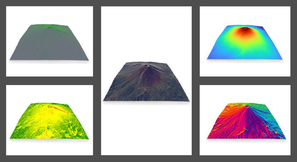
A practical Rhino × GIS workflow for acquiring, processing, analysing, and visualising terrain data using Rhino, Grasshopper, and Heron. By connecting elevation data with geographic context, this project demonstrates how GIS-based terrain data can be used in Rhino to support terrain understanding, spatial analysis, and design workflows.
Overview
This project demonstrates a practical workflow for integrating terrain data into a Rhino × GIS environment.
Rather than using terrain simply as 3D geometry, the workflow connects elevation data with geographic location and spatial reference. Heron is used to acquire terrain data and raster imagery, while Grasshopper is used to process and analyse terrain information such as contours, elevation, slope, and aspect. The resulting terrain and analysis outputs are represented and visualised in Rhino.
The workflow supports terrain visualisation, contour generation, elevation mapping, slope analysis, aspect analysis, and location-aware design workflows.
Objectives
The objectives of this project are to:
- Acquire terrain data using GIS-based data services.
- Import and position terrain data in Rhino using geographic coordinates.
- Define the appropriate Coordinate Reference System (CRS).
- Combine terrain geometry with raster imagery.
- Generate terrain representations such as contours and elevation maps.
- Analyse terrain characteristics such as slope and aspect.
- Demonstrate a practical workflow for incorporating terrain information into spatial and design processes.
Workflow Summary
The workflow consists of five main steps:
- Define a geographic reference location in Rhino using Heron.
- Define the appropriate Coordinate Reference System (CRS).
- Acquire terrain data using Heron in Grasshopper and import it into Rhino.
- Acquire raster imagery and apply it to the terrain model.
- Process terrain data in Grasshopper to generate contours and visualise elevation, slope, and aspect in Rhino.
Rather than treating terrain data as an isolated GIS dataset, this workflow demonstrates how geographic location, elevation data, and Rhino geometry can remain connected throughout the process.
Key Technologies
- Rhino
- Grasshopper
- Heron
- GIS
- Coordinate Reference Systems (CRS)
- WGS84 / EPSG:4326
- Digital Elevation Model (DEM)
- Digital Surface Model (DSM)
- GMRT
- ArcGIS REST Services
- Raster imagery
Key Outcomes
This workflow enables:
- Georeferenced terrain models in Rhino.
- Terrain visualisation using raster imagery.
- Contour generation from terrain data.
- Elevation-based terrain visualisation.
- Slope and aspect visualisation.
- Integration between terrain data and Rhino-based design workflows.
- A practical foundation for terrain-informed spatial decision-making.
Position within My Work
This project represents one practical implementation of my Rhino × GIS approach, demonstrating how terrain data, geographic context, and geometric modelling can be connected within a single spatial workflow.
It also forms part of the Rhino × GIS × AI Framework, where:
Rhino gives form.
GIS gives position.
AI gives inference.
More broadly, this project provides a practical example of Spatial Intelligence Assemblage by reconfiguring GIS-based terrain data through Rhino and Grasshopper into multiple forms of spatial information that can support further understanding and decision-making.
Further Reading
Part 9 — Rhino × GIS Integration: Terrain data acquisition with Grasshopper and Heron (Part 1)
Learn how to distinguish different types of terrain data, acquire terrain data using Heron in Grasshopper, define spatial reference, and combine terrain geometry with raster imagery in Rhino.
→https://www.applicraft.com/tips/rhinoceros/rhinogis9/
Part 10 — Rhino × GIS Integration: Terrain analysis with Grasshopper: contours, elevation, slope, and aspect (Part 2)
Learn how to process terrain data in Grasshopper to generate contours and visualise elevation, slope, and aspect in Rhino.
→https://www.applicraft.com/tips/rhinoceros/rhinogis10/
Related
Rhino × GIS × AI Framework
Explore how Rhino, GIS, and AI work together to support spatial understanding and decision-making.
Spatial Intelligence Assemblage
Learn more about the broader principle behind this workflow and how new forms of spatial intelligence emerge through the relationships between disciplines.